Hurricane Local Statement
Issued by NWS Houston/Galveston, TX
492
WTUS84 KHGX 060259
HLSHGX
TXZ214-313-335>338-436>439-061100-

Tropical Storm Beryl Local Statement Advisory Number 30
National Weather Service Houston/Galveston TX  AL022024
959 PM CDT Fri Jul 5 2024

This product covers Southeast Texas

**BERYL NOW OVER THE SOUTHERN GULF OF MEXICO.. ...HURRICANE WATCH
 EXTENDED TO SAN LUIS PASS AND STORM SURGE WATCH EXTENDED TO HIGH
 ISLAND**


NEW INFORMATION
---------------

* CHANGES TO WATCHES AND WARNINGS:
    - A Storm Surge Watch and Hurricane Watch have been issued for
      Brazoria Islands and Coastal Brazoria
    - A Storm Surge Watch has been issued for Bolivar Peninsula,
      Chambers, Coastal Galveston, Coastal Harris, and Galveston
      Island

* CURRENT WATCHES AND WARNINGS:
    - A Storm Surge Watch is in effect for Bolivar Peninsula,
      Chambers, Coastal Galveston, Coastal Harris, and Galveston
      Island
    - A Storm Surge Watch and Hurricane Watch are in effect for
      Brazoria Islands, Coastal Brazoria, Coastal Jackson, Coastal
      Matagorda, and Matagorda Islands

* STORM INFORMATION:
    - About 600 miles south-southeast of Galveston TX or about 600
      miles southeast of Port O`Connor TX
    - 21.7N 90.2W
    - Storm Intensity 60 mph
    - Movement West-northwest or 295 degrees at 13 mph


SITUATION OVERVIEW
------------------

Tropical Storm Beryl is weakened after traversing the Yucatan
Peninsula, but has emerged over the southwestern Gulf of Mexico.
This will allow for its inner core to recover and allow for gradual
strengthening as the storm traverses the southwestern Gulf of Mexico.
Beryl will spend much of the weekend traveling generally to the
northwest, turning slightly more northward later in the weekend into
Monday morning. The current forecast currently brings the storm to the
Texas Gulf Coast a little below Matagorda Bay as a hurricane around
mid-day Monday.


POTENTIAL IMPACTS
-----------------

* SURGE:
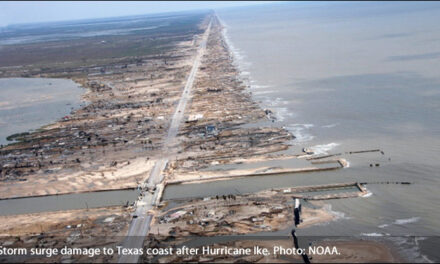
Prepare for life-threatening surge having possible significant
impacts across the Southeast Texas Gulf Coast. Potential impacts in
this area include:
    - Areas of inundation with storm surge flooding accentuated by
      waves. Damage to several buildings, mainly near the coast.
    - Sections of near-shore escape routes and secondary roads become
      weakened or washed out, especially in usually vulnerable low
      spots.
    - Major beach erosion with heavy surf breaching dunes. Strong and
      numerous rip currents.
    - Moderate damage to marinas, docks, boardwalks, and piers.
      Several small craft broken away from moorings, especially in
      unprotected anchorages.

* FLOODING RAIN:
Prepare for dangerous rainfall flooding having possible significant
impacts across the Matagorda Bay area. Potential impacts
include:
    - Moderate rainfall flooding may prompt several evacuations and
      rescues.
    - Rivers and tributaries may quickly become swollen with swifter
      currents and overspill their banks in a few places, especially
      in usually vulnerable spots. Small streams, creeks, canals, and
      ditches overflow.
    - Flood waters can enter some structures or weaken foundations.
      Several places may experience expanded areas of rapid
      inundation at underpasses, low-lying spots, and poor drainage
      areas. Some streets and parking lots take on moving water as
      storm drains and retention ponds overflow. Driving conditions
      become hazardous. Some road and bridge closures.

Prepare for locally hazardous rainfall flooding having possible
limited impacts across the rest of Southeast Texas.

* WIND:
Prepare for life-threatening wind having possible extensive impacts
across the immediate Matagorda Bay coast. Potential impacts in this
area include:
    - Considerable roof damage to sturdy buildings, with some having
      window, door, and garage door failures leading to structural
      damage. Mobile homes severely damaged, with some destroyed.
      Damage accentuated by airborne projectiles. Locations may be
      uninhabitable for weeks.
    - Many large trees snapped or uprooted along with fences and
      roadway signs blown over.
    - Some roads impassable from large debris, and more within urban
      or heavily wooded places. Several bridges, causeways, and
      access routes impassable.
    - Large areas with power and communications outages.

Also, prepare for dangerous wind having possible limited to
significant impacts across most of the rest of Southeast Texas.

* TORNADOES:
Prepare for a tornado event having possible limited impacts across the
Matagorda Bay area. Potential impacts include:
    - The occurrence of isolated tornadoes can hinder the execution
      of emergency plans during tropical events.
    - A few places may experience tornado damage, along with power
      and communications disruptions.
    - Locations could realize roofs peeled off buildings, chimneys
      toppled, mobile homes pushed off foundations or overturned,
      large tree tops and branches snapped off, shallow-rooted trees
      knocked over, moving vehicles blown off roads, and small boats
      pulled from moorings.

Elsewhere across Southeast Texas, little to no impact is anticipated.


PRECAUTIONARY/PREPAREDNESS ACTIONS
----------------------------------

* EVACUATIONS:
Follow the advice of local officials.

* OTHER PREPAREDNESS INFORMATION:
When making safety and preparedness decisions, do not focus on the
exact forecast track since hazards such as flooding rain, damaging
wind gusts, storm surge, and tornadoes extend well away from the
center of the storm.

Always heed the advice of local officials and comply with orders that
are issued. Do not needlessly jeopardize your life or the lives of
others.

If you are a visitor, know the name of the county or parish in which
you are located and where it is relative to current watches and
warnings. If staying at a hotel, ask the management staff about their
onsite disaster plan. Listen for evacuation orders, especially
pertaining to area visitors.

Closely monitor weather.gov, NOAA Weather Radio and local news
outlets for official storm information. Listen for possible changes
to the forecast.

* ADDITIONAL SOURCES OF INFORMATION:
- For information on appropriate preparations see ready.gov
- For information on creating an emergency plan see getagameplan.org
- For additional disaster preparedness information see redcross.org


NEXT UPDATE
-----------

The next local statement will be issued by the National Weather
Service in Houston/Galveston TX around 4 AM CDT, or sooner if
conditions warrant.

$$


